
In this part, you will learn how to use advanced features. In particular, you learn how to save route, to use the graphs, export course and see all the options of the application.
![]()
In "Altimeter 3D", a course is characterized by recording your position throughout your trip. Each recorded point (marker) contains your geographical position, altitude, speed and time traveled. You can always select a marker on the map to view this information. Furthermore, graphics are constructed from these markers.
![]()
During the course, the markers are recorded every time your movement is greater than a reference distance (adjustable in the "Settings" menu: 10m - 50m - 100m). Thus, the distance of the course that can be recorded depends on the acquisition distance. The app records up to 1000 markers on a ride, then we get the following recording distances:
- for 10m : 10Km
- for 50m : 50Km
- for 100m : 100Km
It is therefore necessary to adjust the "distance of acquisition" according to the route that you will perform (10m default).
A course can be recorded once the application is closed and even with the mobile standby. You can disable this feature in the "Settings" menu (default: enabled).
On the other hand, you can keep the screen always on when using the application, again you can disable this feature in the "Settings" menu (default: enabled).
To start recording the route, press the "Start" button.

The recording symbol flashes at the top of the screen.
![]()
Warning, the start of a recording will erase all markers displayed on the map.
Warning, a large number of marker may cause latency for manual movement of the map.
You can, at any time during recording:
- Pause recording (during a pause on the way).

In this case, the pause symbol flashes at the top of the screen. To resume recording, just press "Start" button.
- Add a WayPoint in the recording by pressing the "WayPoint" button. A WayPoint is more visible than other marker, it identifies important places during your trip.
.
When your trip is completed, press the "Stop" button to save.

Remember, once you have finished recording, it is not possible to restart the same route.
You can always open a saved course by pressing the "Courses" button at the bottom right of the "Route" menu.
![]()

During recording, the graphics window allows you to monitor in real time the evolution of your trip. Graphics are updated each time that a marker is recorded.
While editing a previously saved route, the graphs represent the entire course.
"Course"
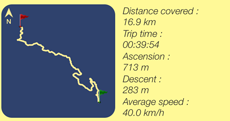
It represents your course in 2D. The green flag is your departure. The red flag is the arrival. You can select a point on the graph and obtain the geographic coordinates of this point. To the right of the graph, the application displays the overall data path.
"Altitude"
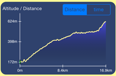
It represents the altitude versus distance or over time traveled. You can select a point on the graph to determine the altitude.
"Speed"
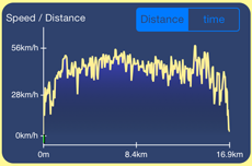
It represents the instantaneous velocity versus distance or over time traveled. You can select a point on the graph to determine the speed.
For each graph a WayPoint is represented by a red circle.
![]()
From the "Graph" menu, it is possible to export data from the course by e-mail by pressing the "Mail" button at the bottom left of the screen.

The exported data can be found with attachments in text and "CSV" format.
The email also contains the three charts of the course.
![]()
To open the "Settings" menu, press the button at the bottom right of the screen.
We will now describe each option.
- Measurement unit:
You can choose to display distances and speeds in meters or in feet or miles.
- Elevation from :
This option is used in the "GPS" mode when the map is centered on your location. It displays either the altitude provided by GPS mobile or by the data server.
Note , in "Manual" mode , the altitude displayed is always the server data.
- Method for measuring the altitude :
This option is used when the altitude display is provided by the data server. Indeed , the server can provide altitude information defined relative to sea level , or ellipsoidal mode .
- Coordinate Format :
This option Allows to display the coordinates in degrees or in degrees , minutes or degrees -minutes- seconds.
- Zoom to display heights :
Viewing heights on the map can be increased (x2 default) . Indeed, it is sometimes better to accentuate the uneven to better analyze a tricky passage .
- Map Type :
5 types of map can be chosen.
Map 1: For cyclists and hiker . Maps provided by OpenCycleMap @ Contributor of OpenStreetMap.org ( ODbL ) .
Map 2: Dedicated skiers . Shows the slopes. Maps provided by OpenPisteMap @ Contributor of OpenStreetMap.org ( ODbL ) .
Map 3: OpenStreetMap OSM Standard . OpenStreetMap.org( ODbL )
Map 4: MapQuest OSM Standard . Maps provided by MapQuest @ Contributor of OpenStreetMap.org ( ODbL ) .
Map 5 : Grid . Simply displays a gray grid.
Tip: You can save the maps before using the application in a place without internet connection. To do this, using an internet connection, you must browse the desired geographical areas on the map. The application saves the plans in a cache memory.
- Minimum distance to record a spot in the path :
Used while recording a route, this option sets the minimum distance to a marker is recorded.
Depending on the selected distance , the maximum length of the route is displayed .
- Keep the screen always switched on :
Use this option to keep the screen always on mobile while using the application.
- Continue recording the race When the implementation is closed :
Use this option to continue recording a route with the application is closed and / or your mobile standby.
- Use sound
To use the sound effects in the application.
- Select sound
Choice of sound effects .
- Cache Size :
Each time you use the application, " Altimeter 3D" saves the altitudes provided by the server and maps information. This allows to optimize the performance of the application , to limit the data connections and use less battery power.
You can always clear the cache .
Design and Realization.
![]()
Design and Realization of
Website
Application Iphone / Ipad / Android