


Description
Finesse Max is a mobile application that measures the fineness of an aircraft.
In aviation, the fineness is defined as the ratio between the distance traveled on the lost height during a glide. This data, unique for aircraft, must be known by the pilot to evaluate how far it can go, depending on the height where it is, in a case of an engine failure.
Based on the measurement taken from the GPS of your mobile, Finesse Max is used in flight and simulating an engine failure. The application saves during the glide, distance traveled and height lost. Thus, at the end of the measurement, the application provided: the average fineness (calculated using the least squares method), average speed adopted for the glide, the glide angle and the graph distance / height and distance / speed. A measurement error indication is also provided in order to properly evaluate the results.
Thus, by successive tests at different speeds, it is possible to determine the best speed to be adopted in case of engine failure to cover the longest distance.
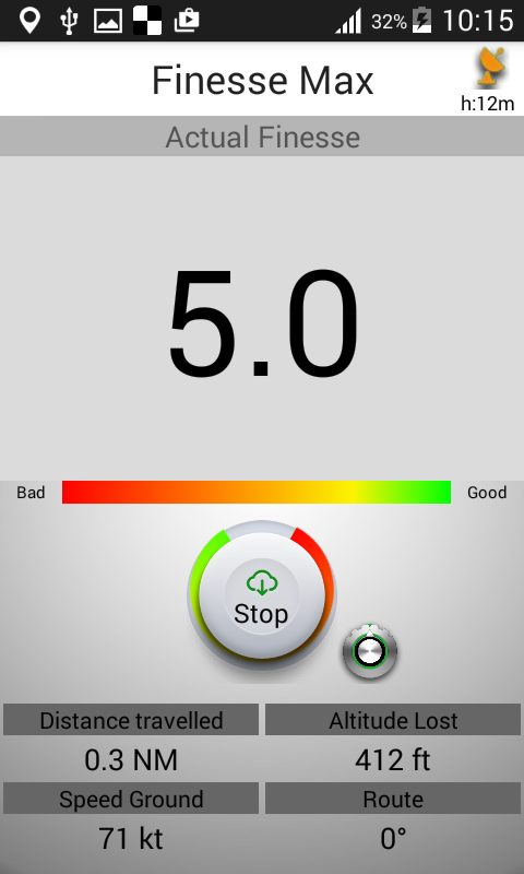
Additionally, Finesse Max indicates during the measurement, instant fineness (on an average of 20s), distance, height lost, ground speed and the route followed by the aircraft.
Measurements can be displayed in different units of measure for distance, height and speed. It is therefore possible to reopen a measurement or sent by email.
Ideally, the application should be used without wind. Indeed, the fineness is defined as the ratio between the distance and height in the air mass, and application measures the ground speed and ground distance, it is necessary to make a real as the air mass does not move (ground speed = airspeed).
CAUTION!
GPS Accuracy
This application is based on measures provided by the GPS of your mobile. It is therefore necessary before any measure favoring a good GPS accuracy. Before undertaking a measure of finesse, make sure that the two upper antennas are green (left antenna: vertical accuracy - right antenna: horizontal accuracy).
Wind
The fineness of an aircraft being defined relative to the air mass, so that the application gives a true value of finesse, it should be used without wind.
Height
For the application to provide proper finesse value, it should make the measurements by losing at least 150m (500ft) high. Therefore provide sufficient altitude to make records. The central circular indicator indicates during the measurement, if the minimum drop height is reached. Do not take a risk! If you are too low, leave the measurement and start again from above.
Speed
When measured, it must maintain a constant glide speed. If this condition is not met, the measure will be wrong.
Instant Fineness
Depending on the quality of reception of GPS, instant finesse displayed during a measurement may give erroneous results. An indicator below the display of instant fineness can appreciate the quality of the displayed measurement. If the indicator moves to the green, the measurement becomes valid. Conversely, if the indicator moves to the red, ignore the measure.
This is not a measuring device!
Celier Aviation France declines any responsibility for the use of this application. Take all necessary precautions to make these measurements safely within the rules of the air.
Conclusion
Observe the rules of the air, always be careful and not take any risks in flight. Voluntarily stop your measure if you do not fly in maximum security conditions.
Good flight and good measures .
Compatibility
Requires Android 3.0 or later.
Phone version


Tablet version


This application is distributed by Celier Aviation France.