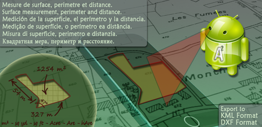


Android application for surface measurement, perimeter and distance.
 |
 |
 |
 |
 |
 |
A2 - DEMO version View and download in Google PLAY |
You have a Iphone/Ipad? View version for Iphone/Ipad |
|
Discover also A2 + |
|||
Description
A2 is an application dedicated to the surface measurement, perimeter and distance. The land measured can be in the world and can be of that magnitude.This application is useful for measuring agricultural land, sports fields, roofs of houses but also lakes, countries, continents etc. ...
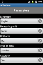
The display area may be: m2, square feet, square yard, Acre, Are and hectare.
A2 can measure and display the perimeter of the ground, intermediate distances and angles between each point. The measurement can be displayed in feet, Inch, Yard or Feet.
A2 can save plans, edit them and export them via e-mail and Bluetooth with the format "KML" (for use with software like Google Earth, Google Maps, Google Mobile, World Wind, Sketchup ... ) and "DXF" (AutoCAD).
A2 uses Google MAP and GPS for geotagging.
A2 has three operating modes:
- GPS : The user is on the ground to measure. He validates many points that best describe the ground through the position provided by GPS.
To enter a point just perform an action on the center red button.

- Manual : the user entries points manually without moving by finding a way on the map.
For this, the user points his finger to enter the place for 1 second.
- Mixed : the user is entering the field and points via GPS and can be added manually (for example access difficult).
- Flexibility of A2 -
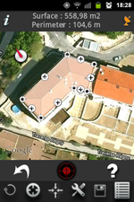
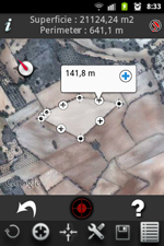
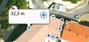
- Viewing the perimeter and intermediate distances :
To display the distance between two points, simply press the '+' symbol. The perimeter is permanently displayed at the top of the screen.
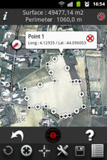
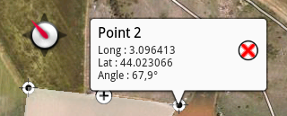
- Angle and Information on a point :
At any time, the user can know the coordinates of the points captured by briefly pressing with your finger the desired point. The angle of this point is displayed below coordinates.
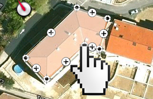
- Moving a point :
Each input point can be moved with your finger to adjust its position.
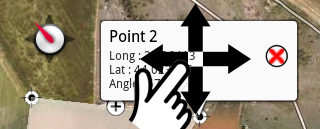
For this, the user touches the point with your finger to move to open the information bubble. Just move the bubble that appears under the cursor. Move the cursor to the new position then release.
- Deleting an entry point:
A point can be deleted individually by holding his finger to press the point, then the emergence of the information bubble, by pressing the "delete" button represented by a red cross.
- Manually inserting a new point between two existing points:
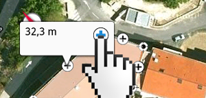
You can insert a new point between two existing points to refine the tracing of the plan. To insert a new point between two existing points, just press on the icon "+" to display the distance between two points, and then press the icon "+". The new point is inserted in the middle of the two existing points. Just move your finger to adjust its position.
- Display of the surface :
The surface is calculated and displayed at each entry point again.
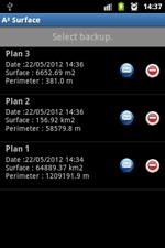
- Archiving of measures:
Each field measured can be archived with a custom name. Each record can be reopened and again be edited.
- Ability to connect an external Bluetooth GPS:
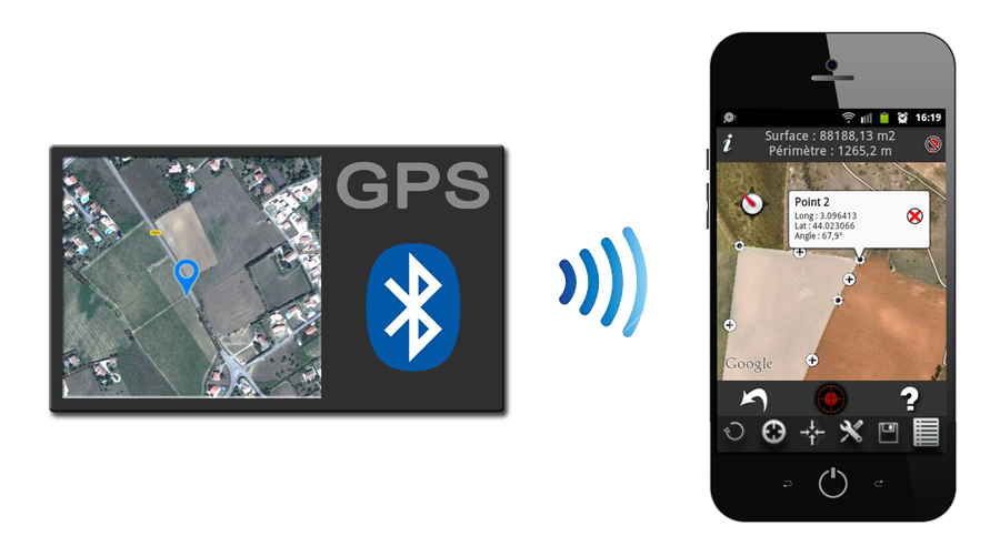
To use an external Bluetooth GPS you should observe the following procedure:
- Pair your bluetooth GPS with your mobile.
- Enable "Allow mock locations" in the "Developer Options" menu of your mobile. If the "Developer Options" menu does not appear in your phone , please visit the Internet to activate it.
- Activate the internal GPS of your mobile in the "Location access" menu of your mobile.
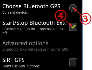
- Select the Bluetooth GPS in the "GPS Setup" menu of A2.
- In A2, Enable Bluetooth GPS via "GPS setup" with the "Start/Stop Bluetooth External GPS" option.
- A2 now receives data from the Bluetooth GPS . You can return to the main page of A2 and use the application.
Note : You can verify that the Bluetooth GPS is working properly by checking this notification at the top left of the screen of your mobile .
- GPS reception indicator :
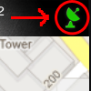
The icon at the top right corner of the application indicates the quality of GPS reception. Green indicates good reception, orange and red mean a poor reception.
- GPS Information :
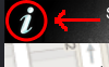
The "information" button will display the location information from GPS.
- Export plans to KML and DXF format :
To export a plan with KML and DXF format, you must go to the backup list and press the icon 'email'. A2+ adds, in the e-mail, the plan attached. You simply write the recipient and send the message.
It is possible to perform export plans stored in the application to import in a new mobile. This function is very useful in case you want to change mobile or just to share your plans with someone else having the app.
To do this, we added two new buttons in the list of saved plans. The first, exports the plans in the "A2 / Export" folder (or "A2plus / Export" for the A2 + application) on your mobile. The second allows recovery plans located in the "A2 / Export" folder (or "A2plus / Export" for the A2 + application) on your mobile.
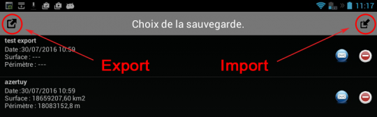
To transfer, simply thus:
- Make an export with the left button.
- Copy the folder "A2 / Export" (or "A2plus / Export" for purposes A2 +) of your device in the new mobile.
- Make an import with the right button with the new mobile.
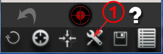
- Down menu :
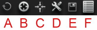
A - Erasing all points. Caution: this operation is irreversible!
B - Centering the map on the current position of the user.
C - Centering the plan on the map.
D - Open menu option measure (see below).
E - Backup Plan.
F - Open backup.
- Options -
Several measurement options are available:
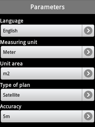
- Choice of language.
- Unit of measure: meter, inch, feet and yard.
- Surface unit : m2, square feet, square yard, Acre, Are, ha.
- Map Type : Map, Satellite, hybrid (map + satellite).
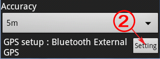
- Accuracy in GPS mode : <100m, <10m, <5m.
This option will not allow to take a point if the GPS accuracy is below the setpoint.
- Configuring the external Bluetooth GPS .
Design and Implementation.
![]()
Design and Realization of
Website
Application Iphone / Ipad / Android