 Loc'All - Geolocation for all!
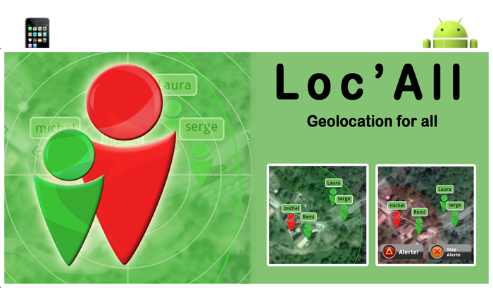
Loc'All is an application allowing the location of a group of persons (your family, your employees, your car fleet, a group of sportsmen, a group of friends, hunters during a hunt, etc.) by GPS. It allows you to view the live position of all users.
Developed mainly for monitoring children, Loc'All allows to define a safety zone around you and so to warm you if a user exits (sound warning).
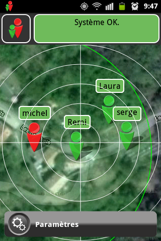
The visualization of a group is made from Google Map in mode plan or satellite. This allows use of both the earliest distant (worldwide). A circular grid can be displayed on the screen in order to better assess the distances between you and other users.
The number of groups is unlimited. The number of people in a group is also unlimited.
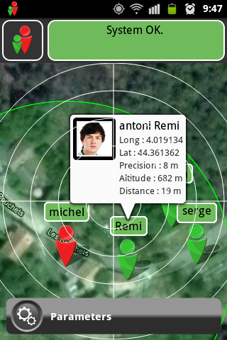
In a group, each user is defined by its name, first name, email address and their photo (optional). Thus, during the location, each user is identified and located precisely (display latitude and longitude of its altitude, precision geolocation and your distance).
During location, it is possible to correspond with each user by mail, phone, skype, sms ect.
The location map can be centered automatically on all users in a group or on your position.
To save battery mobile Loc'All can run in the background with the screen off.
Options
- The display mode map (map or satellite) with the possibility of displaying a circular grid.
- 6 different alert tones in "security zone".
- Automatic centering on the group being geolocation or your position.
- Battery saving mode with use background (screen off).
- Option to keep the screen geolocation (map) always on.
Loc'All available in free version (Loc'All light) for use without a map. This version is primarily intended for users in a group do not need to know the position of other users. It only allows it to geotag by others in the group. This prevents all persons in the group must buy the full version.
How to use Loc'All?
CAUTION: Before you use Loc'All, check that your mobile phone is connected to the Internet (wifi-3G-ect.) and the GPS is activated.
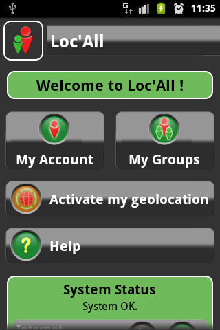
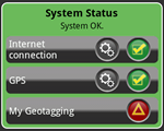 The framework of information at the bottom of the home page tells you if these two conditions are met.
1/ Create an account.

The first step is to create an account by filling in your name, surname, email address and the optional photo.
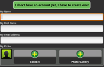
Once the account is created, the application gives you a secret code that will allow you to identify with the other users.
Write this code.
2/ Create a group.

In a second time, you must create the group of people you want to geotag. To do this, you must enter their PIN and optional photo of each user. If you set the photo from your address book, you can correspond with this user (mail, phone, skype, sms ect.) Simply by clicking on his photo.
Each user must do the same on your mobile.
Once a group is created, you can run the geolocation directly by clicking on the button "geolocation".
![]()
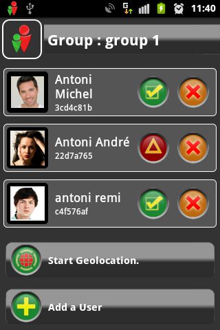
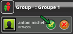
You can see the composition of a group by clicking the group button.
![]()
The composition of a group activity informs users status: Active (geolocation correct) - Off (not yet geolocated) - Unknown (user no longer exists).
 |
Active (geolocation correct) |
 |
Inactive (not yet geolocated). |
 |
Indeterminate (user no longer exists) |
You can then start the geolocation of this group by clicking on the button "geolocation".
It is possible to use the free version (Loc'All light) for users to only be geolocated.
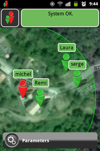
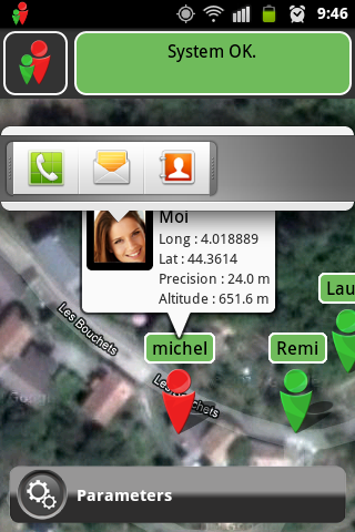
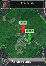
You can then view on the map the location of each user group (green symbol) and be informed on its coordinates (longitude, latitude), altitude, precision positioning and distance from you. To do this, simply press your finger on the user and the information window appears. In this mode, the centering of the card is disabled.
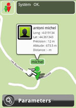
Your position is displayed with the red symbol. You can disable the display of your position in the menu "Settings" at the bottom of the map.
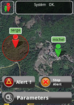
From "Settings" menu at the bottom of the map, you can define a security perimeter. You can enable the sound from 6 types of alerts.
Once activated, a green circle is drawn around you.
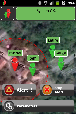
When a user leaves this scope Loc'All notify you by an audible warning. The circle defining the security zone becomes red. It is possible to stop the buzzer by pressing the button "Stop Alert".
From "Settings" menu at the bottom of the map, you can also define if your mobile screen must remain on throughout the geolocation.
For use in low power (screen off, or just out of the application), simply exit the application by pressing the "Home" button on your mobile or also leaving the page (button "Back "your mobile) without disabling geolocation.
This choice is also called out of the application from the home page.
You can know at any time if your geolocation is active by looking at the presence of the logo "Loc'All" in the status bar of your phone. If geolocation is active, simply press the logo in the notification bar of your phone to restart the application.
Design and Realization.
![]()
Design and Realization of
website
Application Iphone / Ipad / Android